
[Paper Review] Sub-Meter Tree Height Mapping of California using Aerial Images and LiDAR-Informed U-Net Model
This study presents a sub-meter resolution canopy height map of California (0.6 m) using a LiDAR-informed U-Net regression model trained on 2020 USDA-NAIP aerial images (60 cm resolution). The model achieves a mean absolute error of 2.9 m across diverse forest types, accurately reconstructing 3D tree structures from nadir-view optical imagery and outperforming existing global canopy height products, even for trees up to 50 m tall.
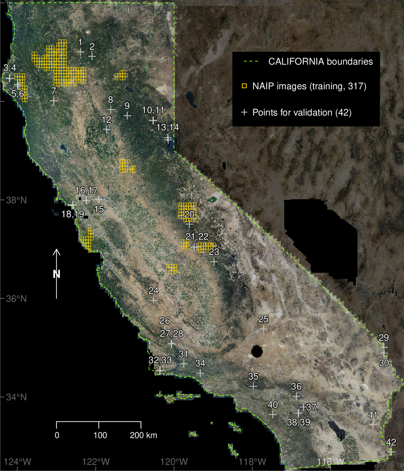
Tree canopy height is one of the most important indicators of forest biomass, productivity, and species diversity, but it is challenging to measure accurately from the ground and from space. Here, we used a U-Net model adapted for regression to map the canopy height of all trees in the state of California with very high-resolution aerial imagery (60 cm) from the USDA-NAIP program. The U-Net model was trained using canopy height models computed from aerial LiDAR data as a reference, along with corresponding RGB-NIR NAIP images collected in 2020. We evaluated the performance of the deep-learning model using 42 independent 1 km$^2$ sites across various forest types and landscape variations in California. Our predictions of tree heights exhibited a mean error of 2.9 m and showed relatively low systematic bias across the entire range of tree heights present in California. In 2020, trees taller than 5 m covered ~ 19.3% of California. Our model successfully estimated canopy heights up to 50 m without saturation, outperforming existing canopy height products from global models. The approach we used allowed for the reconstruction of the three-dimensional structure of individual trees as observed from nadir-looking optical airborne imagery, suggesting a relatively robust estimation and mapping capability, even in the presence of image distortion. These findings demonstrate the potential of large-scale mapping and monitoring of tree height, as well as potential biomass estimation, using NAIP imagery.
Motivation & Objective
- To develop a scalable, high-resolution method for mapping tree canopy height across large forested regions using only optical aerial imagery and limited LiDAR training data.
- To overcome the limitations of coarse global canopy height maps (e.g., 10–30 m resolution) that lack accuracy for local forestry and conservation applications.
- To evaluate whether deep learning can reconstruct 3D tree structure from nadir-view, 2D optical images by learning geometric patterns from LiDAR-derived height references.
- To enable large-scale, sub-meter tree height mapping in California, a region with high forest biomass and biodiversity, for improved carbon stock monitoring and conservation planning.
- To assess the transferability and robustness of the model across diverse forest types and landscape conditions, including mountainous and distorted imaging environments.
Proposed method
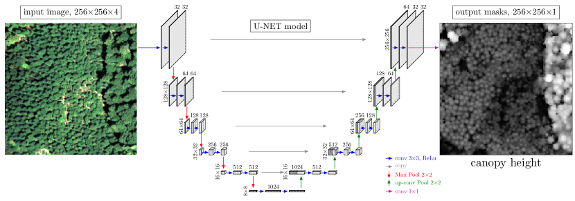
- Trained a U-Net-based convolutional neural network (CNN) for regression to predict canopy height from RGB-NIR NAIP aerial images (60 cm resolution) collected in 2020.
- Used LiDAR-derived canopy height models (CHMs) as ground truth labels for model training, ensuring high-accuracy reference data for tree height estimation.
- Applied data augmentation and normalization techniques to improve model generalization across varied forest types and imaging conditions.
- Employed a single NVIDIA RTX 3090 GPU for training and inference, enabling deployment on standard research hardware without requiring high-end clusters.
- Integrated a pre-existing building footprint dataset to reduce misclassification of structures as vegetation in the reference CHMs.
- Validated model performance across 42 independent 1 km² test sites spanning multiple forest types and topographic conditions in California.
Experimental results
Research questions
- RQ1Can a deep learning model trained on LiDAR-derived canopy height maps reconstruct accurate 3D tree structures from nadir-view, 2D optical aerial images?
- RQ2How does the performance of the U-Net-based regression model compare to existing global canopy height products in terms of spatial resolution and accuracy?
- RQ3To what extent can the model generalize across diverse forest types and landscape variations, including mountainous and image-distorted regions?
- RQ4Can the model estimate tree heights above 40 m without saturation, and how does it perform on the tallest trees in California, such as coast redwoods?
- RQ5Is the model’s architecture and inference pipeline practical for large-scale deployment on standard hardware, enabling broader access for conservation and forestry applications?
Key findings
- The model achieved a mean absolute error (MAE) of 2.9 m in predicting tree canopy height across 42 independent 1 km² validation sites, with low systematic bias across the full range of observed tree heights.
- The model successfully estimated tree heights up to 50 m without saturation, outperforming existing global canopy height products such as the 10 m resolution Sentinel-2 map and 30 m Landsat-based map.
- The model reconstructed 3D tree structures from 2D nadir-view aerial images with high fidelity, enabling individual tree-level metrics such as height and crown size to be extracted.
- In 2020, trees taller than 5 meters covered approximately 19.3% of California, a key metric for biomass and carbon stock assessment.
- The model demonstrated robust performance in mountainous and topographically complex regions where image distortion is common, suggesting resilience to geometric distortions in VHR imagery.
- The model’s inference and training pipeline is efficient and deployable on a single high-end GPU (NVIDIA RTX 3090), making it accessible to most research and conservation institutions.
Better researchstarts right now
From reading papers to final review, dramatically reduce your research time.
No credit card · Free plan available
This review was created by AI and reviewed by human editors.