[论文解读] TorchSpatial: A Location Encoding Framework and Benchmark for Spatial Representation Learning
TorchSpatial 提供一个统一框架(LocBench)用于位置编码器,在地理感知任务上进行基准测试,并推出 Geo-Bias Score 用于量化空间表示学习中的地理偏见。
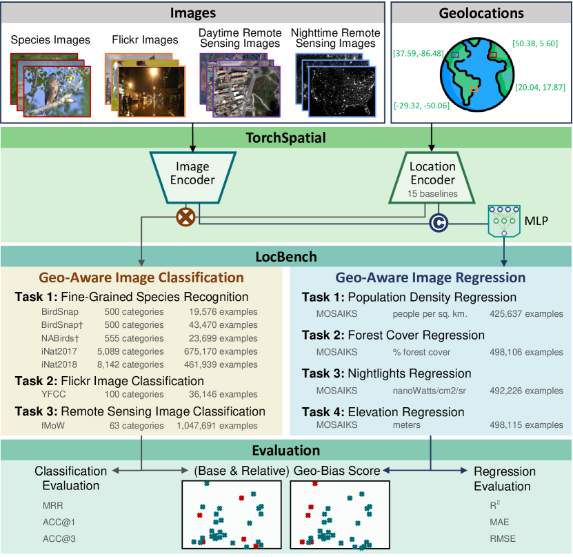
Spatial representation learning (SRL) aims at learning general-purpose neural network representations from various types of spatial data (e.g., points, polylines, polygons, networks, images, etc.) in their native formats. Learning good spatial representations is a fundamental problem for various downstream applications such as species distribution modeling, weather forecasting, trajectory generation, geographic question answering, etc. Even though SRL has become the foundation of almost all geospatial artificial intelligence (GeoAI) research, we have not yet seen significant efforts to develop an extensive deep learning framework and benchmark to support SRL model development and evaluation. To fill this gap, we propose TorchSpatial, a learning framework and benchmark for location (point) encoding, which is one of the most fundamental data types of spatial representation learning. TorchSpatial contains three key components: 1) a unified location encoding framework that consolidates 15 commonly recognized location encoders, ensuring scalability and reproducibility of the implementations; 2) the LocBench benchmark tasks encompassing 7 geo-aware image classification and 10 geo-aware image regression datasets; 3) a comprehensive suite of evaluation metrics to quantify geo-aware model's overall performance as well as their geographic bias, with a novel Geo-Bias Score metric. Finally, we provide a detailed analysis and insights into the model performance and geographic bias of different location encoders. We believe TorchSpatial will foster future advancement of spatial representation learning and spatial fairness in GeoAI research. The TorchSpatial model framework and LocBench benchmark are available at https://github.com/seai-lab/TorchSpatial, and the Geo-Bias Score evaluation framework is available at https://github.com/seai-lab/PyGBS.
研究动机与目标
- 引入一个统一的位置编码框架,整合 15 种编码器,以实现可扩展、可重复的 SRL 发展。
- 提供 LocBench:一个基准测试套件,包含 7 个地理感知的图像分类数据集和 4 个地理感知的图像回归数据集,用于系统评估。
- 开发一个通用的 Geo-Bias Score 框架,以在跨空间的模型性能中量化地理偏见。
- 分析不同位置编码器在多样化地理覆盖和数据集规模下的性能与地理偏见。
提出的方法
- 将 Enc(x) = NN(PE(x)) 定义为在灵活框架内对位置编码器进行形式化。
- 在 TorchSpatial 框架中实现 15 种广泛使用的 2D/3D 位置编码器。
- 将 LocBench 组装为包含 7 个地理感知的图像分类数据集和 4 个地理感知的图像回归数据集。
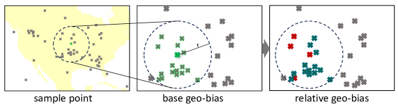
- 基于空间自信息(SSI)开发 Geo-Bias 分数,用以在多个空间尺度上量化基础偏差和相对地理偏见。
- 在不同数据集上评估编码器对整体性能和地理偏见的影响,报告这两种指标及偏差分析。
实验结果
研究问题
- RQ1不同位置编码器如何影响地理感知任务的整体模型性能?
- RQ2位置编码器的选择如何影响跨空间的模型预测中的地理偏见?
- RQ3地理感知的改进是否在多样化数据集和空间尺度上保持一致?
- RQ4Geo-Bias Score 框架是否能够为 SRL 模型提供通用的地理偏见度量?
主要发现
- 增加位置编码器通常会提升跨地理感知任务的模型性能。
- 某些编码器(例如 Sphere2Vec 的变体)在多个数据集上实现了最先进的结果,而其他编码器在偏置方面的影响则有所不同。
- Geo-Bias 分数显示,与不使用位置的基线相比,大多数编码器会增加地理偏见,且在数据集和尺度之间存在差异。
- 在细粒度地理感知图像分类方面,GPT-4V 的表现不及微调模型。
- Geo-Bias 框架在多个空间尺度(例如 100 km、1000 km、最近邻)上捕捉基础数据集偏差和编码器特定偏差。
- 定性热点分析显示地理性能模式在很大程度上由数据集的空间分布驱动,而非编码器的选择。
更好的研究,从现在开始
从论文设计到论文写作,大幅缩短您的研究时间。
无需绑定信用卡
本解读由 AI 生成,并经人工编辑审核。