
[论文解读] Deep Learning for Slum Mapping in Remote Sensing Images: A Meta-analysis and Review
本论文对来自遥感数据的贫民窟映射的深度学习方法进行了系统的荟萃分析(2014–2024),总结了架构、数据源、预处理和挑战,以指导未来研究。
The major Sustainable Development Goals (SDG) 2030, set by the United Nations Development Program (UNDP), include sustainable cities and communities, no poverty, and reduced inequalities. However, millions of people live in slums or informal settlements with poor living conditions in many major cities around the world, especially in less developed countries. To emancipate these settlements and their inhabitants through government intervention, accurate data about slum location and extent is required. While ground survey data is the most reliable, such surveys are costly and time-consuming. An alternative is remotely sensed data obtained from very high-resolution (VHR) imagery. With the advancement of new technology, remote sensing based mapping of slums has emerged as a prominent research area. The parallel rise of Artificial Intelligence, especially Deep Learning has added a new dimension to this field as it allows automated analysis of satellite imagery to identify complex spatial patterns associated with slums. This article offers a detailed review and meta-analysis of research on slum mapping using remote sensing imagery from 2014 to 2024, with a special focus on deep learning approaches. Our analysis reveals a trend towards increasingly complex neural network architectures, with advancements in data preprocessing and model training techniques significantly enhancing slum identification accuracy. We have attempted to identify key methodologies that are effective across diverse geographic contexts. While acknowledging the transformative impact Convolutional Neural Networks (CNNs) in slum detection, our review underscores the absence of a universally optimal model, suggesting the need for context-specific adaptations. We also identify prevailing challenges in this field, such as data limitations and a lack of model explainability and suggest potential strategies for overcoming these.
研究动机与目标
- 推动获取用于面向可持续发展目标的城市规划的准确贫民窟位置与范围数据。
- 综合在多样化情境中用于遥感贫民窟映射的深度学习方法。
- 识别提高贫民窟检测的的数据源、预处理工作流和模型架构。
- 突出挑战(数据局限性、可解释性)并提出推进策略。
提出的方法
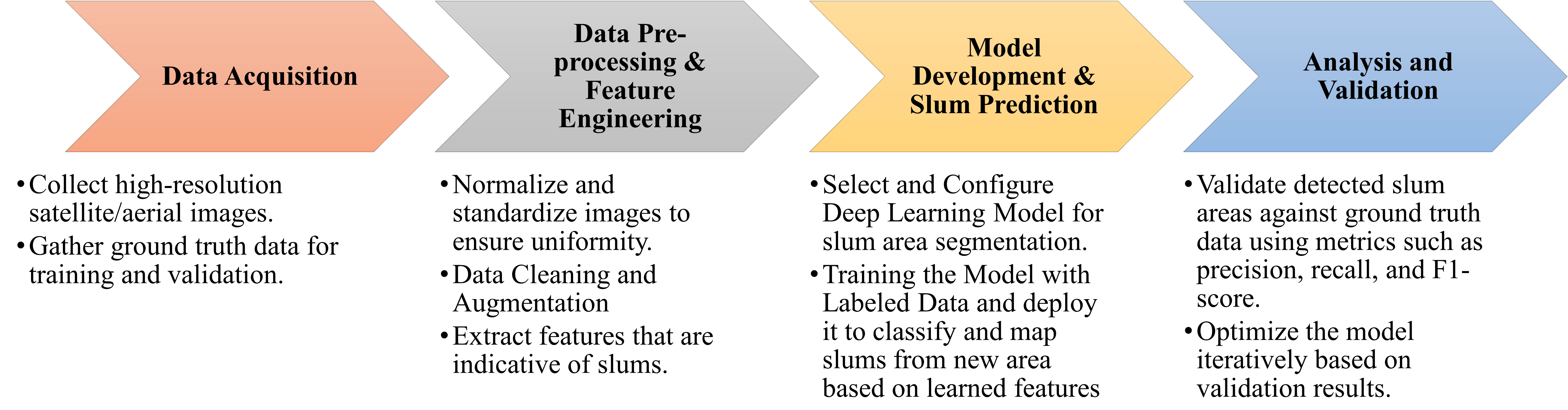
- 在 Web of Science、Scopus 和 ScienceDirect 上进行系统性文献综述。
- 使用与贫民窟、非正式住区、遥感、卫星影像、深度学习或神经网络相关的关键词进行检索。
- 基于 PRISMA 的筛选,选择在英文全文中具有充分方法细节(2014–2024)的相关研究。
- 提取并综合40篇符合条件的文献,分析地区、数据集、预处理和模型结构。
- 对架构和训练实践进行元分析综合,以识别趋势和空白。
- 讨论与 GIS 的整合以及伦理方面的考量。
![Figure 1: Geographic distribution of the proportion of urban populations residing in slums by country [ 7 ] . The color gradient indicates the percentage, with darker shades representing higher proportions. The absence of colors denotes the unavailability of data.](https://ar5iv.labs.arxiv.org/html/2406.08031/assets/geographic.png)
实验结果
研究问题
- RQ1在哪些地区,贫民窟映射的深度学习研究对其模型进行了训练和测试?
- RQ2用于贫民窟映射的深度学习的数据源和数据集有哪些?
- RQ3这些模型的训练和测试数据是如何准备的(预处理、增强、类别不平衡等)?
- RQ4预测模型的结构是什么(架构、训练方案、迁移学习)?
- RQ5当前存在的主要挑战和局限性是什么,提出了哪些应对策略?
主要发现
- 趋势趋向于采用越来越复杂的神经网络架构用于贫民窟映射。
- 数据预处理和模型训练技术显著提升贫民窟识别的准确性。
- 不存在普遍最优的模型;需要针对特定地理情境进行调整。
- 数据局限性和缺乏模型可解释性仍是该领域的关键挑战。
- 元分析涵盖了多样的区域和数据源,表明将 DL 应用于贫民窟映射的应用正在快速但处于初级阶段发展。
- PRISMA 流程图和表 I 总结了研究选择和期刊分布。
更好的研究,从现在开始
从阅读论文到最终审阅,大幅缩短您的研究时间。
无需绑定信用卡
本解读由 AI 生成,并经人工编辑审核。