
[论文解读] Infomap Bioregions 2 - Exploring the interplay between biogeography and evolution
本文介紹了 Infomap Bioregions 2,這是一種基於網絡的方法,透過根據物種或格網單元之間的連結權重,並將祖先節點連接到其後代物種所在的格網單元,將系統發育樹整合至物種出現網絡中。透過納入演化關係,該方法產生更具生物學現實性、更穩健且具有層次嵌套結構的生物區,揭示出以演化為基礎的獨特、重疊且模糊的空間模式,這些模式在僅基於分佈的方法中無法檢測到。
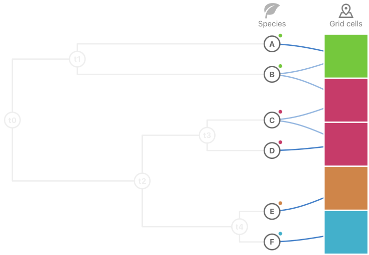
Identifying and understanding the large-scale biodiversity patterns in time and space is vital for conservation and addressing fundamental ecological and evolutionary questions. Network-based methods have proven useful for simplifying and highlighting important structures in species distribution data. However, current network-based biogeography approaches cannot exploit the evolutionary information available in phylogenetic data. We introduce a method for incorporating evolutionary relationships into species occurrence networks to produce more biologically informative and robust bioregions. To keep the bipartite network structure where bioregions are grid cells indirectly connected through shared species, we incorporate the phylogenetic tree by connecting ancestral nodes to the grid cells where their descendant species occur. To incorporate the whole tree without destroying the spatial signal of narrowly distributed species or ancestral nodes, we weigh tree nodes by the geographic information they provide. For a more detailed analysis, we enable integration of the evolutionary relationships at a specific time in the tree. By sweeping through the phylogenetic tree in time, our method interpolates between finding bioregions based only on distributional data and finding spatially segregated clades, uncovering evolutionarily distinct bioregions at different time slices. We also introduce a way to segregate the connections between evolutionary branches at a selected time to enable exploration of overlapping evolutionarily distinct regions. We have implemented these methods in Infomap Bioregions, an interactive web application that makes it easy to explore the possibly hierarchical and fuzzy patterns of biodiversity on different scales in time and space.
研究动机与目标
- 解決現有基於網絡的生物區劃方法的限制,這些方法忽略演化關係,對所有物種一視同仁,不考慮系統發育。
- 透過將系統發育結構納入生物區劃檢測,減少物種分類衝突與稀疏數據過度擬合所帶來的偏倚。
- 實現檢測不僅空間一致,且在演化上獨特的生物區,特別是針對範圍受限或單系群特異的模式。
- 透過在系統發育樹中掃描,插值介於僅基於分佈與基於單系群的生物區之間,探索跨時間的生物區模式。
- 使用高階網絡分割技術可視化重疊與層次結構的生物區,從而實現非排他性、具演化資訊的生物地理單元。
提出的方法
- 構建格網單元與物種之間的雙分圖網絡,其中連結代表物種出現,並根據每個物種的地理範圍加權連結,以減少廣泛物種的主導影響。
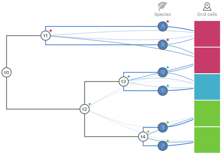
- 透過將祖先節點連接到其現存後代物種所出現的所有格網單元,整合完整的系統發育樹,從而保留現存與祖先類群的空間信號。
- 根據其提供的地理資訊對祖先節點進行加權,確保具有演化資訊但地理上受限的單系群能對生物區劃檢測產生顯著貢獻。
- 透過在特定演化時間點整合系統發育樹,實現時間切片分析,允許在基於分佈的生物區與基於單系群的生物區之間進行插值。
- 使用高階網絡的分割方法,於選定時間點約束演化分支內的路徑,從而實現對重疊、演化上獨特生物區的檢測。
- 在 Infomap Bioregions 2 中實現完整工作流程,這是一項互動式網絡應用程式,透過色彩編碼與透明度可視化層次性、模糊性與重疊的生物區,以指示過渡區域與穩健性。
实验结果
研究问题
- RQ1如何系統性地將系統發育關係整合至物種出現網絡中,以超越分佈相似性,改善生物區劃檢測?
- RQ2納入演化歷史在多大程度上能減少物種分類衝突與稀疏數據所導致的偏倚?
- RQ3時間切片整合系統發育樹是否能揭示隨演化時間變化而演變的演化上獨特的生物區?
- RQ4由不同演化譜系定義的重疊生物區如何在空間中出現並共存?它們又如何可視化?
- RQ5根據地理分佈對物種與祖先節點進行加權,對檢測到的生物區之穩健性與生物學現實性有何影響?
主要发现
- 將完整的系統發育樹整合至物種出現網絡中,可產生更具穩健性與生物學現實性的生物區,特別是在分布範圍受限的單系群中表現更佳。
- 該方法降低了廣泛物種的影響,這些物種在標準基於網絡的生物區劃中通常會主導並導致模塊結構崩潰。
- 透過根據地理資訊對祖先節點加權,該方法保留了現存物種及其演化祖先的空間信號。
- 時間切片整合允許在僅基於物種分佈的生物區與基於空間分離單系群的生物區之間進行插值,從而揭示動態的演化模式。
- 分割方法使重疊生物區的檢測成為可能,例如在澳洲,多個演化譜系共同貢獻於不同但共存的生物地理單元。
- 互動式網絡應用程式 Infomap Bioregions 2 成功可視化了層次性、模糊性與重疊的生物區,透過透明度與混合色彩突出過渡區域。
更好的研究,从现在开始
从阅读论文到最终审阅,大幅缩短您的研究时间。
无需绑定信用卡
本解读由 AI 生成,并经人工编辑审核。