
[论文解读] Kuro Siwo: 33 billion $m^2$ under the water. A global multi-temporal satellite dataset for rapid flood mapping
Kuro Siwo 是一个全球分布的多时相合成孔径雷达(SAR)数据集,包含32起洪水事件,覆盖630亿平方米陆地,其中包含121亿平方米的洪水或永久水体区域,具有高质量的人工标注。该数据集支持通过监督学习和自监督深度学习实现快速洪水制图,在水体检测中达到最高87%的F1分数,并通过BlackBench基准设定了强有力的基线表现。
Global floods, exacerbated by climate change, pose severe threats to human life, infrastructure, and the environment. Recent catastrophic events in Pakistan and New Zealand underscore the urgent need for precise flood mapping to guide restoration efforts, understand vulnerabilities, and prepare for future occurrences. While Synthetic Aperture Radar (SAR) remote sensing offers day-and-night, all-weather imaging capabilities, its application in deep learning for flood segmentation is limited by the lack of large annotated datasets. To address this, we introduce Kuro Siwo, a manually annotated multi-temporal dataset, spanning 43 flood events globally. Our dataset maps more than 338 billion $m^2$ of land, with 33 billion designated as either flooded areas or permanent water bodies. Kuro Siwo includes a highly processed product optimized for flood mapping based on SAR Ground Range Detected, and a primal SAR Single Look Complex product with minimal preprocessing, designed to promote research on the exploitation of both the phase and amplitude information and to offer maximum flexibility for downstream task preprocessing. To leverage advances in large scale self-supervised pretraining methods for remote sensing data, we augment Kuro Siwo with a large unlabeled set of SAR samples. Finally, we provide an extensive benchmark, namely BlackBench, offering strong baselines for a diverse set of flood events from Europe, America, Africa, Asia and Australia.
研究动机与目标
- 解决深度学习在洪水制图中缺乏大规模、高质量标注SAR数据集的问题。
- 利用SAR数据实现全球多样化条件下全天候、全天候运行的快速准确洪水制图,无论昼夜或天气状况。
- 通过提供强基线的基准测试,加速自动化洪水检测与响应研究。
- 通过发布大规模未标注SAR数据集与精心筛选的标注数据,同时支持监督学习与自监督学习。
- 通过使模型能够泛化至多个大洲的未见洪水事件,提升灾害响应与风险评估能力。
提出的方法
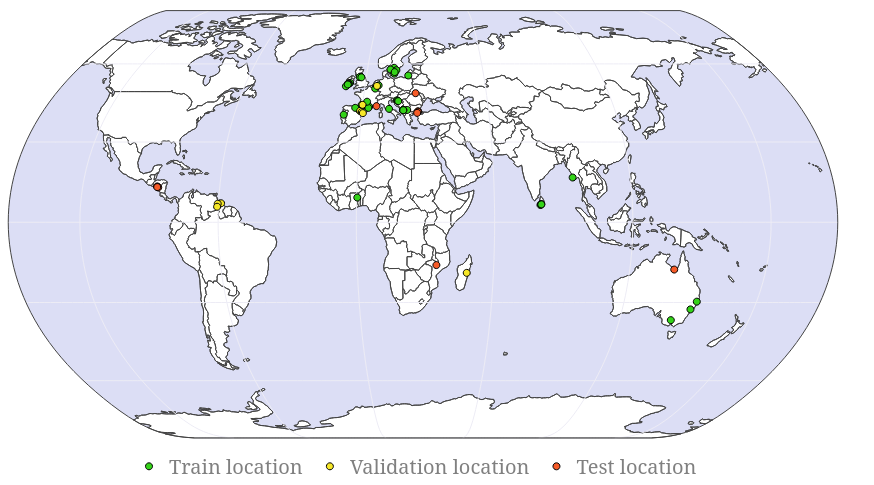
- 整理一个全球范围的多时相SAR数据集,涵盖欧洲、美洲、非洲和澳大利亚的32起洪水事件,包含双极化SAR数据与高程数据。
- 利用高分辨率SAR影像与来自CEMS及其他来源的交叉验证实地真值,对洪水区域和永久水体进行细致的人工标注。
- 通过整合灾前、灾中和灾后SAR影像,引入时间上下文信息,以提升模型泛化能力与时间推理性能。
- 开发BlackBench,一个统一的基准测试平台,用于评估洪水分割模型在未见地理区域与多样化环境条件下的表现。
- 通过发布大规模未标注SAR数据集,支持自监督预训练,以提升模型鲁棒性与迁移学习性能。
- 在Kuro Siwo数据集上训练并评估最先进的模型(如FloodViT-Decoder与SNUNet-CD),以建立高性能基线。
实验结果
研究问题
- RQ1一个具有高质量标注的全球多样化、多时相SAR数据集,是否能显著提升深度学习模型在快速洪水制图中的性能?
- RQ2时间上下文(灾前、灾中、灾后)的引入在多大程度上影响模型的泛化能力与分割精度?
- RQ3在大规模未标注SAR数据上进行自监督预训练,能在多大程度上提升下游洪水检测性能?
- RQ4为何模型在动态河流环境中的永久水体与洪水区域之间难以区分?
- RQ5在Kuro Siwo上训练的模型是否能有效泛化至不同大陆与环境条件下的未见洪水事件?
主要发现
- Kuro Siwo在洪水区域检测中达到约85%的F1分数,在一般水体检测中达到87%,表明标注质量高且模型性能优异。
- 在测试集上,即使面对地理与气候条件多样的未见事件,基于Kuro Siwo训练的模型在洪水区域检测中F1分数仍超过82%,在二值水体检测中超过85%。
- 包含所有可用灾前SAR影像显著提升了模型性能,凸显了时间上下文在洪水分割中的重要性。
- FloodViT-Decoder在所有测试模型中取得最高的平均交并比(IoU),而SNUNet-CD表现相当,表明其具备强大的基线能力。
- 在检测永久水体方面出现显著性能下降,尤其是在动态河流系统中,原因在于难以区分其与洪水区域,以及SAR影像中的斑点噪声。
- 定性分析显示,被淹没的河岛与小型、移动的水体区域难以被准确分割,表明当前模型在嘈杂SAR条件下对细粒度、动态水体特征的分辨能力有限。
更好的研究,从现在开始
从阅读论文到最终审阅,大幅缩短您的研究时间。
无需绑定信用卡
本解读由 AI 生成,并经人工编辑审核。