
[论文解读] Global geoid model GGM2022
本文提出GGM2022,一种基于浅层法(Shen方法)的5′×5′全球大地水准面模型,通过采用改进的地壳密度(CRUST-re)、高分辨率地形(DTM2006.0)和EGM2008重力场模型,对地球浅层质量层进行建模,从而提升大地水准面精度。GGM2022在北美、欧洲和中国西部等区域对GPS/水准测量数据的拟合效果优于EGM2008,尤其在地形复杂、高程较高的地区表现更优。
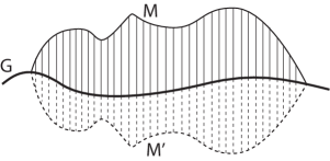
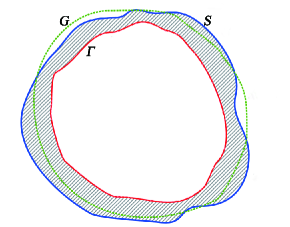
We provide an updated 5 $^\prime $ $ imes $ 5 $^\prime $ global geoid model GGM2022, which is determined based on the shallow layer method (Shen method). First, we choose an inner surface $Γ$ below the EGM2008 global geoid by 15 m, and the layer bounded by the inner surface $Γ$ and the Earth's geographical surface $S$ is referred to as the shallow layer. The Earth's geographical surface $S$ is determined by the digital topographic model DTM2006.0 combining with the DNSC2008 mean sea surface. Second, we formulate the 3D shallow mass layer model using the refined 5 $^\prime $ $ imes $ 5 $^\prime $ crust density model CRUST$_-$re , which { is an improved 5 $^\prime $ $ imes $ 5 $^\prime $ density model of the CRUST2.0 or CRUST1.0 with taking into account the corrections of the areas covered by ice sheets and the land-ocean crossing regions. Third, based on the shallow mass layer model and the gravity field EGM2008 that is defined in the region outside the Earth's geographical surface $S$, we determine the gravity field model EGM2008s that is defined in the whole region outside the inner surface $Γ$, where the definition domain of the gravity field is extended from the domain outside $S$ to the domain outside $Γ$. Fourth, based on the gravity field EGM2008s and the geodetic equation $W(P)=W_0$ (where $W_0$ is the geopotential constant on the geoid and $P$ is the point on the geoid $G$), we determine a 5 $^\prime $ $ imes $ 5 $^\prime $ global geoid, which is referred to as GGM2022. Comparisons show that the GGM2022 fits the globally available GPS/leveling data better than EGM2008 global geoid in the USA, Europe and the western part of China.
研究动机与目标
- 通过克服传统Stokes法与Molodensky法的局限性,开发更高精度的全球大地水准面模型。
- 减少大地水准面确定过程中因质量调整和外部质量建模引起的误差。
- 在地形复杂且地壳密度变化显著的区域,特别是高海拔地区,提升大地水准面精度。
- 利用全球GPS/水准测量基准点评估新大地水准面模型的性能。
- 建立一个未来基于更新重力场与地壳密度模型的大地水准面建模框架。
提出的方法
- 定义一个位于EGM2008大地水准面下方15米的内表面Γ,以形成Γ与地球表面S之间的浅层质量层。
- 利用改进的5′×5′ CRUST-re地壳密度模型构建三维浅层质量层模型,包含冰盖和陆海过渡区域的修正。
- 通过引入浅层质量层的重力位能,将重力场模型EGM2008外推至Γ区域之外,得到EGM2008s。
- 利用EGM2008s求解大地测量方程W(P) = W₀,计算每个5′×5′网格点处的大地水准面差距N。
- 使用来自美国、欧洲、澳大利亚和中国西部的GPS/水准测量数据对模型进行验证。
- 应用浅层法以避免质量调整,确保大地水准面保持为等位势面。
实验结果
研究问题
- RQ1浅层法能否产生比传统基于Stokes方法更精确的全球大地水准面?
- RQ2改进的地壳密度建模(CRUST-re)在高海拔及构造复杂的区域如何影响大地水准面精度?
- RQ3GGM2022在拟合真实世界GPS/水准测量数据方面,相较于EGM2008在不同地形与地质条件下的表现如何?
- RQ4地形起伏与变化的地壳密度对大地水准面确定精度有何影响?
- RQ5浅层法能否系统性地应用于未来基于更新重力场与地壳密度数据的大地水准面模型?
主要发现
- 在北美地区,GGM2022对GPS/水准测量数据的拟合优于EGM2008,尤其在高海拔区域精度更高。
- 在新疆地区(中国西部),GGM2022与GPS/水准测量数据之间大地水准面差距的标准差为17.8 cm(使用CRUST2.0)和18.9 cm(使用CRUST1.0),均低于EGM2008的19.1 cm。
- 在新疆地区,GGM2022的均方根(RMS)误差低于EGM2008,证实了其精度的提升。
- 在澳大利亚(2,638个点)和北欧(146个点)地区,GGM2022的表现与EGM2008相当,表明其在低起伏区域的稳健性。
- GGM2022的改进在高海拔地区最为显著,因为该区域地形与密度效应更为突出。
- 采用CRUST-re——一种改进的5′×5′地壳密度模型——通过更准确地表征浅层质量分布,显著提升了大地水准面精度。
更好的研究,从现在开始
从阅读论文到最终审阅,大幅缩短您的研究时间。
无需绑定信用卡
本解读由 AI 生成,并经人工编辑审核。