[논문 리뷰] TorchSpatial: A Location Encoding Framework and Benchmark for Spatial Representation Learning
TorchSpatial은 위치 인코더를 위한 통합 프레임워크(LocBench), 지오인식 태스크 전반의 벤치마크, 공간 표현 학습에서 지리적 편향을 정량화하는 Geo-Bias Score를 소개한다.
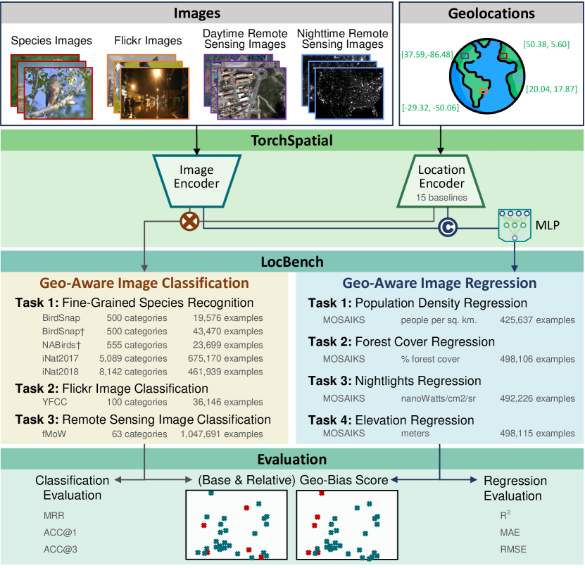
Spatial representation learning (SRL) aims at learning general-purpose neural network representations from various types of spatial data (e.g., points, polylines, polygons, networks, images, etc.) in their native formats. Learning good spatial representations is a fundamental problem for various downstream applications such as species distribution modeling, weather forecasting, trajectory generation, geographic question answering, etc. Even though SRL has become the foundation of almost all geospatial artificial intelligence (GeoAI) research, we have not yet seen significant efforts to develop an extensive deep learning framework and benchmark to support SRL model development and evaluation. To fill this gap, we propose TorchSpatial, a learning framework and benchmark for location (point) encoding, which is one of the most fundamental data types of spatial representation learning. TorchSpatial contains three key components: 1) a unified location encoding framework that consolidates 15 commonly recognized location encoders, ensuring scalability and reproducibility of the implementations; 2) the LocBench benchmark tasks encompassing 7 geo-aware image classification and 10 geo-aware image regression datasets; 3) a comprehensive suite of evaluation metrics to quantify geo-aware model's overall performance as well as their geographic bias, with a novel Geo-Bias Score metric. Finally, we provide a detailed analysis and insights into the model performance and geographic bias of different location encoders. We believe TorchSpatial will foster future advancement of spatial representation learning and spatial fairness in GeoAI research. The TorchSpatial model framework and LocBench benchmark are available at https://github.com/seai-lab/TorchSpatial, and the Geo-Bias Score evaluation framework is available at https://github.com/seai-lab/PyGBS.
연구 동기 및 목표
- 15개 인코더를 통합하는 통합 위치 인코딩 프레임워크를 도입하여 확장 가능하고 재현 가능한 SRL 개발을 가능하게 한다.
- LocBench를 제공: 체계적 평가를 위한 7개의 지리인식 이미지 분류 및 4개의 지리인식 이미지 회귀 데이터셋으로 구성된 벤치마크 스위트.
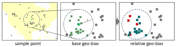
- 공간 전반의 모델 성능에서 지리적 편향을 정량화하기 위한 보편적인 Geo-Bias Score 프레임워크를 개발한다.
- 다양한 지리 범위와 데이터셋 크기에 걸친 서로 다른 위치 인코더의 성능과 지리적 편향을 분석한다.
제안 방법
- Enc(x) = NN(PE(x))를 정의하여 유연한 프레임워크 내에서 위치 인코더를 형식화한다.
- TorchSpatial 프레임워크 안에 널리 사용되는 2D/3D 위치 인코더 15개를 구현한다.
- LocBench를 7개의 지리인식 이미지 분류 및 4개의 지리인식 이미지 회귀 데이터셋으로 구성한다.
- 다중 공간 스케일에서 기본 지리 편향과 상대적 지리 편향을 정량화하기 위해 공간 자기정보(SSI)에 기반한 Geo-Bias Scores를 개발한다.
- 데이터셋 전반에 걸친 전반적 성능과 지리적 편향에 대한 인코더의 영향을 평가하고 두 지표와 편향 분석을 보고한다.
실험 결과
연구 질문
- RQ1다양한 위치 인코더가 지리인식 태스크에서 전체 모델 성능에 어떤 영향을 미치는가?
- RQ2위치 인코더의 선택이 공간에 걸친 모델 예측의 지리적 편향에 어떤 영향을 미치는가?
- RQ3다양한 데이터셋과 공간 규모에서 지리인식 개선이 일관되는가?
- RQ4Geo-Bias Score 프레임워크가 SRL 모델의 지리적 편향에 대한 보편적 척도를 제공할 수 있는가?
주요 결과
- 위치 인코더를 추가하면 일반적으로 지리인식 태스크에서 모델 성능이 향상된다.
- 일부 인코더(예: Sphere2Vec 변형)는 여러 데이터셋에서 최첨단 결과를 달성하는 반면, 다른 인코더는 편향에 대해 혼합 효과를 보인다.
- Geo-Bias Scores는 대부분의 인코더가 위치 비무관 기반 대비 지리 편향을 증가시키며 데이터셋과 규모에 따라 차이가 있음을 보여준다.
- GPT-4V는 파인튜닝된 모델에 비해 미세한 지리인식 이미지 분류에서 성능이 떨어진다.
- Geo-Bias 프레임워크는 여러 공간 스케일(예: 100 km, 1000 km, 이웃과의 거리에 따른 편향)을 통해 기본 데이터셋 편향과 인코더별 편향을 포착한다.
- 정성적 핫스팟 분석은 지리적 성능 패턴이 주로 인코더 선택보다는 데이터셋의 공간 분포에 의해 좌우됨을 보여준다.
더 나은 연구,지금 바로 시작하세요
연구 설계부터 논문 작성까지, 연구 시간을 획기적으로 줄여보세요.
카드 등록 없음 · 무료 플랜 제공
이 리뷰는 AI가 만들고, 인간 에디터가 검토했습니다.