
[論文レビュー] Dry-to-Wet Soil Gradients Enhance Convection and Rainfall over Subtropical South America
本研究は、数十kmのスケールの乾燥から湿潤への土壌水分(SM)勾配が、熱帯南アメリカにおける対流および降雨を強化する仕組みを明らかにした。この勾配は、メソスケールの気圧環流を生成し、より乾燥した土壌上での深層対流を引き起こす。土壌水分-降水量(SM-PPT)フィードバックの符号は、背景風速に強く依存しており、弱い風では負のフィードバック(降雨が乾燥域に限定される)となり、強い風では伝播が可能になり、正のフィードバック(降雨が風下に発生)となる。これは、対流スケールモデルの構築に大きな課題を提示する。
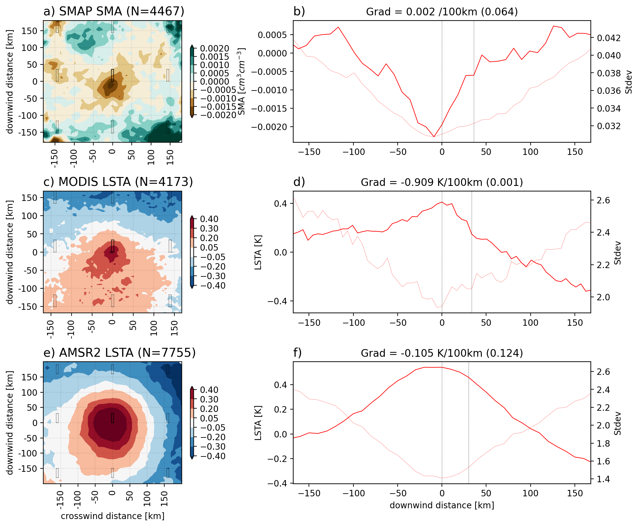
Soil moisture-precipitation (SM-PPT) feedbacks at the mesoscale represent a major challenge for numerical weather prediction, especially for subtropical regions that exhibit large variability in surface SM. How does surface heterogeneity, specifically mesoscale gradients in SM and land surface temperature (LST), affect convective initiation (CI) over South America? Using satellite data, we track nascent, daytime convective clouds and quantify the underlying antecedent (morning) surface heterogeneity. We find that convection initiates preferentially on the dry side of strong SM/LST boundaries with spatial scales of tens of kilometers. The strongest alongwind gradients in LST anomalies at 30 km length scale underlying the CI location occur during weak background low-level wind (<2.5m/s), high convective available potential energy (>1500J/kg) and low convective inhibition (<250J/kg) over sparse vegetation. At 100 km scale, strong gradients occur at the CI location during convectively unfavorable conditions and strong background flow. The location of PPT is strongly sensitive to the strength of the background flow. The wind profile during weak background flow inhibits propagation of convection away from the dry regions leading to negative SM-PPT feedback whereas strong background flow is related to longer lifecycle and rainfall hundreds of kilometers away from the CI location. Thus, the sign of the SM-PPT feedback is dependent on the background flow. This work presents the first observational evidence that CI over subtropical South America is associated with dry soil patches on the order of tens of kilometers. Convection-permitting numerical weather prediction models need to be examined for accurately capturing the effect of SM heterogeneity in initiating convection over such semi-arid regions.
研究の動機と目的
- 南米亜熱帯地域におけるメソスケールの土壌水分(SM)および地表面温度(LST)の不均一性が、対流発生(CI)に与える影響を理解すること。
- 背景風、CAPE、CINが対流スケールにおけるSM-PPTフィードバックをどのように調節するかを定量化すること。
- SM/LST勾配の空間スケール(30 km 対 100 km)が、対流および降雨に与える感受性を評価すること。
- 植生被覆および地形が、不均一な表面におけるメソスケール循環およびCIに与える影響を評価すること。
- 背景気流に依存するSM-PPTフィードバックの符号に関する観測的証拠を提供し、対流許容モデルの改善に寄与すること。
提案手法
- 南米亜熱帯地域全域で、日中の新生対流雲を衛星データを用いて追跡し、対流発生(CI)の位置を特定した。
- SMおよびLSTの異常を、30 kmおよび100 kmの空間スケールで、前日朝の表面不均一性を分析した。
- 複数の衛星データセットを用いた:降水量にはGPM-IMERG、土壌水分にはSMAP、LSTにはMODISおよびAMSR2、風速・CAPE・CINにはERA5を用いた。
- 背景風速の異なる条件下で、LST異常(LSTA)の風下勾配を計算し、CI発生確率との相関関係を評価した。
- 背景風速を弱い(≤2.5 m/s)と強い(>2.5 m/s)に分類し、フィードバックの符号を評価した。
- CI発生後24時間以内の降水量異常をマッピングし、伝播およびフィードバック強度を評価した。

実験結果
リサーチクエスチョン
- RQ1南米亜熱帯地域において、湿潤地域に隣接する乾燥土壌域に、対流が特に発生するか?
- RQ230 kmおよび100 kmスケールのSM/LST勾配が、メソスケール循環およびCI発生確率に与える影響は何か?
- RQ3背景風速がSM-PPTフィードバックの符号を決定づける役割を果たすか?
- RQ4植生被覆および地形は、SM不均一性が対流を誘発する効果をどのように調節するか?
- RQ5乾燥域から湿潤域への対流の伝播が、降水量の空間パターンおよびフィードバック符号にどの程度影響を及ぼすか?
主な発見
- 対流は、強いSM/LST勾配の乾燥側に特に発生し、特に背景風が弱いかつ30 kmスケールの条件下で顕著である(<2.5 m/s)。
- 最も強い風下LST勾配(30 kmスケール)は、高CAPE(>1500 J/kg)かつ低CIN(<250 J/kg)の条件下で発生し、特に植生が乏しい地域でCIを促進する。
- 100 kmスケールでは、強い背景風(>2.5 m/s)下でも、混合効果を打ち破るためにメソスケール循環を生成することで、対流発生が可能になる。
- 複雑な地形では、100 kmスケールのSM不均一性が、東部アンデスおよびブラジル高地で上昇気流を誘発し、斜面風と対立する。
- 背景風が弱い場合、対流は乾燥域に固定され、負のSM-PPTフィードバック(乾燥土壌上での降雨)を示す。
- 背景風が強い場合、対流システムは風下に数km以上伝播し、正のSM-PPTフィードバックおよびCI発生位置から離れた地域での降雨を引き起こす。
より良い研究を、今すぐ始めましょう
論文の読解から最終レビューまで、研究時間を劇的に削減しましょう。
クレジットカード登録不要
このレビューはAIが作成し、人間の編集者が確認しました。