
[論文レビュー] Scalable Semantic 3D Mapping of Coral Reefs with Deep Learning
本論文は、エゴモーション動画を用いた、スケーラブルで低コストな自動的意味的3Dマッピングパイプラインを提示する。学習ベースの構造からモーション(SfM)とディープラーニングによる意味的セグメンテーションを統合することで、100 mの動画トレースを5分未満で高精度な3D点群に変換し、密な意味的ラベルを付与する。この手法により、人的コストと計算コストを削減し、大規模なサンゴ礁モニタリングを可能にする。
Coral reefs are among the most diverse ecosystems on our planet, and are depended on by hundreds of millions of people. Unfortunately, most coral reefs are existentially threatened by global climate change and local anthropogenic pressures. To better understand the dynamics underlying deterioration of reefs, monitoring at high spatial and temporal resolution is key. However, conventional monitoring methods for quantifying coral cover and species abundance are limited in scale due to the extensive manual labor required. Although computer vision tools have been employed to aid in this process, in particular SfM photogrammetry for 3D mapping and deep neural networks for image segmentation, analysis of the data products creates a bottleneck, effectively limiting their scalability. This paper presents a new paradigm for mapping underwater environments from ego-motion video, unifying 3D mapping systems that use machine learning to adapt to challenging conditions under water, combined with a modern approach for semantic segmentation of images. The method is exemplified on coral reefs in the northern Gulf of Aqaba, Red Sea, demonstrating high-precision 3D semantic mapping at unprecedented scale with significantly reduced required labor costs: a 100 m video transect acquired within 5 minutes of diving with a cheap consumer-grade camera can be fully automatically analyzed within 5 minutes. Our approach significantly scales up coral reef monitoring by taking a leap towards fully automatic analysis of video transects. The method democratizes coral reef transects by reducing the labor, equipment, logistics, and computing cost. This can help to inform conservation policies more efficiently. The underlying computational method of learning-based Structure-from-Motion has broad implications for fast low-cost mapping of underwater environments other than coral reefs.
研究の動機と目的
- フォト・クアドラットや動画トレースの手作業分析に起因する、サンゴ礁モニタリングにおけるスケーラビリティのボトルネックを解消すること。
- 従来の構造からモーション(SfM)および意味的セグメンテーションの限界を乗り越え、エンドツーエンドの3D意味的マッピングを実現するため、学習ベースのSfMとディープラーニングを統合すること。
- 高価な機器や専門的労働力、複雑な物流に依存しない、低コストで完全自動のパイプラインにより、サンゴ礁モニタリングの民主化を図ること。
- 気候変動に脆弱な地域(例:アコバ湾北西部)における保護政策やレジリエンス評価を支援するため、高解像度で大規模な生態モニタリングを可能にすること。
- 利用可能な動画データとディープラーニングを用いて、サンゴ礁に限らない水中環境のスケーラブルで自動化された3Dマッピングの基盤を構築すること。
提案手法
- ダイバーに装着したコンsumer級アクションカメラによるエゴモーション動画を用いて、GPSや専用ハードウェアを必要としないサンゴ礁の映像を収集する。
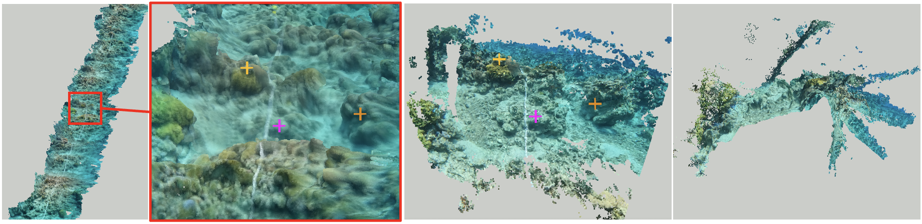
- モノクローラル動画から3Dジオメトリとカメラポーズを推定する学習ベースのSfMシステムを採用し、ループクロージャーやグローバル最適化を必要とせず、リアルタイム再構成を実現する。
- モノクローラル深度推定とビジョアルオドメトリのためのディープニューラルネットワークを統合し、動画シーケンスから正確な3D点群を生成する。
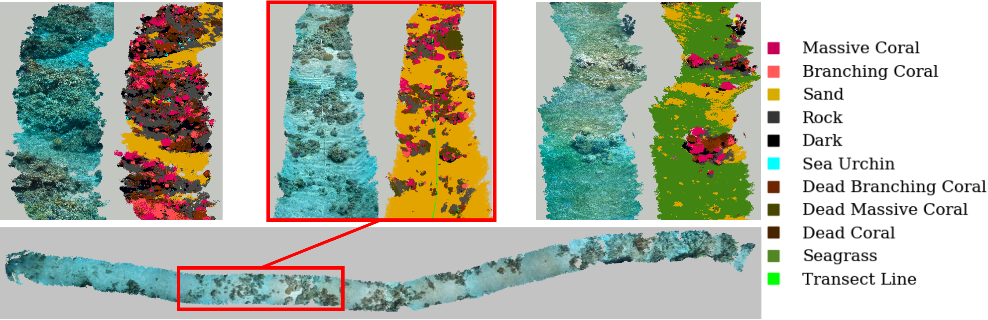
- 最先端の意味的セグメンテーションモデルを用いて、砂地や海藻、コケムシなど底生特徴を高精度に分類する。
- 予測された3Dジオメトリと意味的ラベルを統合し、各点がその底生クラスにラベル付けされた意味的3D点群を生成する。
- スーパーレゾリューション技術を用いて深度推定を精緻化し、ディープラーニング推論における解像度制限を補償する。
実験結果
リサーチクエスチョン
- RQ1完全自動で学習ベースのSfMパイプラインが、エゴモーション動画のみを用いても、サンゴ礁の生態的モニタリングに十分な幾何的正確性を達成できるか?
- RQ2可変な照明条件や水質条件下でも、ディープラーニングによる意味的セグメンテーションモデルが、水中動画フレームにおける底生クラスをどれほど正確に分類できるか?
- RQ3従来の手作業または半自動手法と比較して、本手法のパイプラインは、生動画から意味的3D点群に変換する段階でどれほどスケーラブルで効率的か?
- RQ4GPSやループクロージャーを一切使用しない状況でも、視認可能なトレースマーカーのみに依存して、地理的に正確な3D再構成が可能か?
- RQ5本フレームワークは、深海探査など他の水中エコシステムや応用分野へどのように拡張可能か?
主な発見
- ダイビング5分間で撮影された100 mの動画トレースが、本手法のパイプラインを用いて5分未満で完全に意味的3D点群に変換可能である。
- 高い空間的正確性と意味的セグメンテーション性能を達成しており、底生被覆率や種の分布の正確な定量的評価が可能である。
- 従来のフォト・クアドラットや手作業による動画分析手法と比較して、人的コストとロジスティクスの複雑さが顕著に削減された。
- 著者らは、アコバ湾北西部からのエゴモーション動画の大規模データセットに加え、底生セグメンテーション用に詳細にアノテートされたベンチマークデータセットを公開している。
- 高価なセンサーやGPSを必要としないにもかかわらず、低視界や可変な照明条件といった困難な水中環境でも、本手法は頑健であることが示された。
- 十分なアノテート済み動画データが入手可能な限り、本フレームワークはマングローブ林や深海地域など、他の水中環境へも一般化可能である。
より良い研究を、今すぐ始めましょう
論文の読解から最終レビューまで、研究時間を劇的に削減しましょう。
クレジットカード登録不要
このレビューはAIが作成し、人間の編集者が確認しました。