[論文レビュー] TorchSpatial: A Location Encoding Framework and Benchmark for Spatial Representation Learning
TorchSpatial は、位置エンコーダ、地理情報を考慮したタスクのベンチマーク、空間表現学習における地理的バイアスを定量化する Geo-Bias Score を提供する統一フレームワーク(LocBench)を提示します。
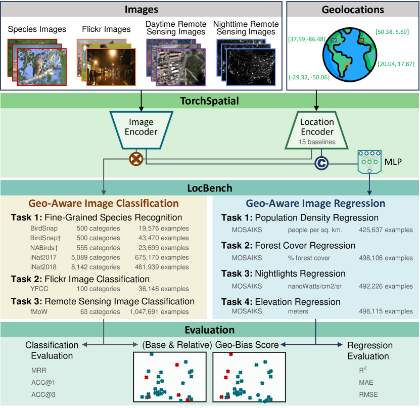
Spatial representation learning (SRL) aims at learning general-purpose neural network representations from various types of spatial data (e.g., points, polylines, polygons, networks, images, etc.) in their native formats. Learning good spatial representations is a fundamental problem for various downstream applications such as species distribution modeling, weather forecasting, trajectory generation, geographic question answering, etc. Even though SRL has become the foundation of almost all geospatial artificial intelligence (GeoAI) research, we have not yet seen significant efforts to develop an extensive deep learning framework and benchmark to support SRL model development and evaluation. To fill this gap, we propose TorchSpatial, a learning framework and benchmark for location (point) encoding, which is one of the most fundamental data types of spatial representation learning. TorchSpatial contains three key components: 1) a unified location encoding framework that consolidates 15 commonly recognized location encoders, ensuring scalability and reproducibility of the implementations; 2) the LocBench benchmark tasks encompassing 7 geo-aware image classification and 10 geo-aware image regression datasets; 3) a comprehensive suite of evaluation metrics to quantify geo-aware model's overall performance as well as their geographic bias, with a novel Geo-Bias Score metric. Finally, we provide a detailed analysis and insights into the model performance and geographic bias of different location encoders. We believe TorchSpatial will foster future advancement of spatial representation learning and spatial fairness in GeoAI research. The TorchSpatial model framework and LocBench benchmark are available at https://github.com/seai-lab/TorchSpatial, and the Geo-Bias Score evaluation framework is available at https://github.com/seai-lab/PyGBS.
研究の動機と目的
- スケーラブルで再現性の高い SRL 開発を可能にする 15 個のエンコーダを統合した統一的な位置エンコーディングフレームワークを導入する。
- LocBench を提供する: 系統的な評価のための 7 つの geo-aware 画像分類データセットと 4 つの geo-aware 画像回帰データセットを備えたベンチマークスイート。
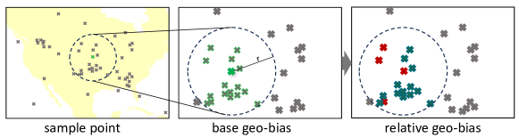
- 空間全体でモデルの性能における地理的バイアスを定量化する普遍的な Geo-Bias Score フレームワークを開発する。
- 多様な地理的カバレッジとデータセットサイズに跨る異なる位置エンコーダの性能と地理的バイアスを分析する。
提案手法
- Enc(x) = NN(PE(x)) を定義して、柔軟なフレームワーク内で位置エンコーダを形式化する。
- TorchSpatial フレームワーク内に 15 個の広く使用されている 2D/3D の位置エンコーダを実装する。
- LocBench を 7 の geo-aware 画像分類データセットと 4 の geo-aware 画像回帰データセットで構成する。
- 空間自己情報量 (SSI) に基づく Geo-Bias Score を開発し、複数の空間スケールで基礎地理的バイアスと相対的な地理的バイアスを定量化する。
- データセット全体での性能と地理的バイアスに対するエンコーダの影響を評価し、両方の指標とバイアス分析を報告する。
実験結果
リサーチクエスチョン
- RQ1さまざまな位置エンコーダは geo-aware タスクにおける全体的なモデル性能にどのような影響を与えるか。
- RQ2位置エンコーダの選択は、空間全体でのモデル予測の地理的バイアスにどのような影響を与えるか。
- RQ3geo-aware の改善は、多様なデータセットと空間スケールを跨って一貫しているか。
- RQ4Geo-Bias Score フレームワークは SRL モデルの地理的バイアスを普遍的に測定できるか。
主な発見
- 位置エンコーダを追加すると、一般に geo-aware タスクでのモデル性能が向上する。
- いくつかのエンコーダ(例:Sphere2Vec 系)は複数のデータセットで最先端の結果を達成する一方で、他はバイアスに対する影響が混在する。
- Geo-Bias Score は、ほとんどのエンコーダが位置非依存のベースラインと比較して地理的バイアスを増加させることを示し、データセットとスケールによって変動する。
- GPT-4V は微細な geo-aware 画像分類においてファインチューニング済みモデルと比較してパフォーマンスが劣る。
- The Geo-Bias フレームワークは、複数の空間スケール(例:100km、1000km、最近傍)にわたり、ベースデータセットのバイアスとエンコーダ特有のバイアスを捉える。
- 定性的なホットスポット分析は、エンコーダの選択よりもデータセットの空間分布により地理的な性能パターンが大きく影響を受けることを示している。
より良い研究を、今すぐ始めましょう
論文設計から論文執筆まで、研究時間を劇的に削減しましょう。
クレジットカード登録不要
このレビューはAIが作成し、人間の編集者が確認しました。