
[Paper Review] USat: A Unified Self-Supervised Encoder for Multi-Sensor Satellite Imagery
USat introduces a unified self-supervised vision transformer encoder for multi-sensor satellite imagery that handles spectral bands with varying ground sampling distances (GSD) without downscaling. By using sensor-specific patchification, superpositional positional encodings, and independent patch projection per band, USatMAE achieves state-of-the-art performance on remote sensing benchmarks, improving accuracy by up to 8% and showing strong gains in low-data regimes.
Large, self-supervised vision models have led to substantial advancements for automatically interpreting natural images. Recent works have begun tailoring these methods to remote sensing data which has rich structure with multi-sensor, multi-spectral, and temporal information providing massive amounts of self-labeled data that can be used for self-supervised pre-training. In this work, we develop a new encoder architecture called USat that can input multi-spectral data from multiple sensors for self-supervised pre-training. USat is a vision transformer with modified patch projection layers and positional encodings to model spectral bands with varying spatial scales from multiple sensors. We integrate USat into a Masked Autoencoder (MAE) self-supervised pre-training procedure and find that a pre-trained USat outperforms state-of-the-art self-supervised MAE models trained on remote sensing data on multiple remote sensing benchmark datasets (up to 8%) and leads to improvements in low data regimes (up to 7%). Code and pre-trained weights are available at https://github.com/stanfordmlgroup/USat .
Motivation & Objective
- To address the limitation of single-sensor self-supervised pre-training in remote sensing, which restricts model generalization and underutilizes complementary multi-sensor data.
- To develop a flexible encoder that can process spectral bands from multiple sensors with differing spatial resolutions (GSD) without downscaling, preserving spatial scale and information.
- To improve downstream performance on remote sensing tasks, especially in low-data regimes, by leveraging richer self-supervision from multi-sensor, multi-spectral data.
- To enable fine-tuning with arbitrary subsets of spectral bands and sensors, increasing model adaptability for diverse downstream applications.
- To overcome sequence length and memory inefficiencies in existing multi-sensor models by reducing sequence length through GSD-aware patchification and superpositional encodings.
Proposed method
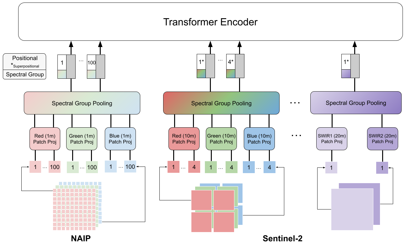
- USat employs a vision transformer with sensor-specific patch projection layers that adaptively divide each spectral band into patches based on its ground sampling distance (GSD), ensuring higher-resolution bands contribute more patches.
- It applies superpositional positional encodings to model the hierarchical spatial structure of multi-GSD inputs, allowing higher-resolution bands to retain fine-grained spatial information.
- Patch embeddings from different spectral bands are combined via a spectral group pooling layer before being summed with positional encodings to form the final patch tokens for the transformer encoder.
- The model is pre-trained using a masked autoencoding (MAE) objective on multi-sensor data (e.g., Sentinel-2 and NAIP), reconstructing masked patches from the full input.
- The architecture supports arbitrary subsets of spectral bands and sensors during both pre-training and fine-tuning, enabling flexible downstream adaptation.
- The method avoids downscaling low-GSD (high-resolution) bands, preserving spatial detail lost in prior approaches that uniformly resize inputs.
Experimental results
Research questions
- RQ1Can a unified self-supervised encoder effectively integrate multi-sensor, multi-spectral satellite imagery with varying ground sampling distances (GSD) without downscaling?
- RQ2Does jointly pre-training on multiple sensors (e.g., Sentinel-2 and NAIP) improve downstream performance compared to single-sensor pre-training?
- RQ3Can a GSD-aware patchification and superpositional encoding scheme reduce sequence length and memory usage while preserving spatial information?
- RQ4How does USatMAE perform in low-data regimes compared to supervised and single-sensor MAE baselines?
- RQ5To what extent can the model be flexibly fine-tuned using arbitrary subsets of spectral bands from multiple sensors?
Key findings
- USatMAE outperforms state-of-the-art self-supervised MAE models on multiple remote sensing benchmarks, achieving up to 8% higher accuracy on average.
- On the USatlas dataset, USatMAE achieved 1.26 mAP improvement over supervised baselines and 0.41 mAP improvement over standard MAE.
- In low-data regimes, USatMAE improved performance by up to 7% compared to standard MAE, demonstrating strong few-shot generalization.
- The model achieved a 2.97 MAP improvement on METER-ML over supervised learning and a 3.16 MAP improvement over standard MAE.
- Joint pre-training on both Sentinel-2 and NAIP sensors outperformed pre-training on either sensor alone, confirming the benefit of multi-sensor self-supervision.
- By avoiding downscaling of high-resolution bands, USatMAE preserves spatial detail and avoids information loss inherent in prior multi-sensor approaches.

Better researchstarts right now
From reading papers to final review, dramatically reduce your research time.
No credit card · Free plan available
This review was created by AI and reviewed by human editors.