
[Paper Review] A scalable system to measure contrail formation on a per-flight basis
This paper presents a scalable, automated system to detect and match persistent contrails from GOES-16 satellite infrared imagery with individual flight segments, enabling per-flight assessment of contrail formation across 1.6 million flights. The key contribution is a large-scale empirical benchmark showing that imperfections in current weather-based contrail prediction models increase the cost of contrail avoidance by about an order of magnitude, despite its overall cost-effectiveness.
Persistent contrails make up a large fraction of aviation's contribution to global warming. We describe a scalable, automated detection and matching (ADM) system to determine from satellite data whether a flight has made a persistent contrail. The ADM system compares flight segments to contrails detected by a computer vision algorithm running on images from the GOES-16 Advanced Baseline Imager. We develop a 'flight matching' algorithm and use it to label each flight segment as a 'match' or 'non-match'. We perform this analysis on 1.6 million flight segments. The result is an analysis of which flights make persistent contrails several orders of magnitude larger than any previous work. We assess the agreement between our labels and available prediction models based on weather forecasts. Shifting air traffic to avoid regions of contrail formation has been proposed as a possible mitigation with the potential for very low cost/ton-CO2e. Our findings suggest that imperfections in these prediction models increase this cost/ton by about an order of magnitude. Contrail avoidance is a cost-effective climate change mitigation even with this factor taken into account, but our results quantify the need for more accurate contrail prediction methods and establish a benchmark for future development.
Motivation & Objective
- To develop a scalable, automated method to determine whether individual flights form persistent contrails using satellite and flight data.
- To create a large-scale empirical benchmark for evaluating contrail prediction models by comparing observed contrails to model predictions.
- To quantify how inaccuracies in weather forecast data—especially relative humidity—impact the cost-effectiveness of contrail avoidance strategies.
- To assess the performance of existing contrail prediction models using real-world observations rather than modeled inputs.
- To provide a foundation for improving contrail prediction and validating future mitigation strategies.
Proposed method
- Utilizes computer vision models trained on GOES-16 Advanced Baseline Imager (ABI) infrared imagery to detect persistent contrails.
- Applies a flight matching algorithm that links detected contrails to flight segments based on spatial and temporal proximity, with thresholds optimized for accuracy.
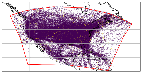
- Processes 1.6 million flight segments across the contiguous U.S. over 168 hours of satellite data.
- Compares observed contrail matches to predictions from multiple contrail formation models using weather forecasts and reanalysis data.
- Employs precision and recall metrics to evaluate model performance against the empirical ground truth.
- Uses a dataset of 1.6 million flight segments and 12,000 detected contrails to establish a benchmark for future model development.
Experimental results
Research questions
- RQ1What fraction of flights in the continental U.S. produce persistent contrails, and how does this vary by time of day, season, and flight density?
- RQ2How accurately do current weather-based models predict contrail formation when validated against real satellite observations?
- RQ3To what extent do errors in upper-atmosphere humidity forecasts degrade the performance of contrail prediction models?
- RQ4How does the imperfection of prediction models affect the cost-effectiveness of air traffic rerouting to avoid contrail formation?
- RQ5Can a scalable, automated system reliably link satellite-detected contrails to individual flight segments at scale?
Key findings
- The system successfully identified contrail formation for 1.6 million flight segments, representing an order of magnitude more data than any prior study.
- Approximately 10% of flights produced persistent contrails, with higher rates during daytime and in high-density air traffic regions.
- Contrail prediction models based on weather forecasts showed significant performance gaps, with precision and recall varying widely depending on the input data source.
- Imperfections in upper-atmosphere relative humidity forecasts were found to increase the cost per ton of CO2-equivalent avoided by about an order of magnitude.
- Despite this, contrail avoidance remains highly cost-effective, with benefits estimated to be 1,000 times greater than costs, even with model errors.
- The study establishes a new benchmark dataset and methodology for evaluating and improving future contrail prediction models.
Better researchstarts right now
From reading papers to final review, dramatically reduce your research time.
No credit card · Free plan available
This review was created by AI and reviewed by human editors.